Wayfinding may be defined as all of the ways in which people orient themselves in physical space, navigate from place to place and interpret their surroundings.
It is a holistic concept with a focus on making all parts of the urban landscape easy to read and understand. Wayfinding in the conventional sense includes elements such as physical signage, some electronic signage, use of landmarks as navigational aids, and certain types of tactile features that employ the sense of touch.
While conventional wayfinding offers some benefits, the newest approaches incorporate multisensory feedback. In addition, the latest handheld technology applications can provide pedestrians and other street users with a richer and more nuanced urban experience. Scholars of environmental design also acknowledge the advantages of using multisensory wayfinding to discover layered information tied to place[1] that may not be possible to access relying on vision alone. This topic focuses on how designers can find ways to build upon recent concepts in conventional wayfinding, incorporate new and emerging technology, and incorporate factors of sound, sight, touch, smell – and even the sense of taste – in our wayfinding experiences of streets.
The Need for Wayfinding
Street wayfinding is essential to address the need of people to orient themselves in the landscape, navigate between destinations and to understand their next move. Different wayfinding elements are necessary to create a street environment where information seamlessly fills navigational gaps, heightens the sense of place and helps people interpret their surroundings. Wayfinding allows both the pedestrian and people using all other types of transportation to successfully navigate the environment.
“If the street and building do their job, it is legible. Elements of the street and buildings contribute to understanding the city.” Kevin Lynch’s understanding of the role of buildings and streets in wayfinding has had tremendous impact on the evolution of wayfinding design. Lasting mental images of the city are dependent on the legibility of the urban fabric and the clarity of the following five spatial-organizing features:
- Paths: Channels by which people move along in their travels (e.g., roads, trails, and sidewalks).
- Edges: All other lines not included in the path group (e.g., walls and seashores).
- Districts: Sections of the city, usually substantial in size, which have an identifying character about them.
- Nodes: Points or strategic spots where there is an extra focus, or an added concentration of city features (e.g., a busy intersection or a popular city center).
- Landmarks: External physical objects that act as reference points (e.g., store, mountain, school, or any other object that aids in orientation when way-finding).
The human ability to perceive the environment depends on the strength of our physical senses – hearing, seeing, touching, smelling and tasting – and the body’s ability to transmit information to processing centers in our brains. Over half of the brain is devoted directly or indirectly to vision[2], meaning we rely primarily on sight to perceive the world around us. That said, the immense amount of visual information available to us is overwhelming, and we’ve consequently adapted to limit what we take in. For example, on any given street, a person will scan a setting and glance at particular points for less than two-tenths of a second before moving onto the next thing, pausing only for things relevant to them or that address their needs.
The physical limits of human vision and competitive visual environment creates the need for effective and creative wayfinding design. Universal design principles[3] in combination with Lynch’s contributions to wayfinding provide a framework for rethinking wayfinding. The concept of “less is more” should also be emphasized – too many wayfinding features compete for our attention. Information overload happens when the streetscape is chaotic or unclear, and a great deal of information must be scanned in order to get the information that is actually needed.
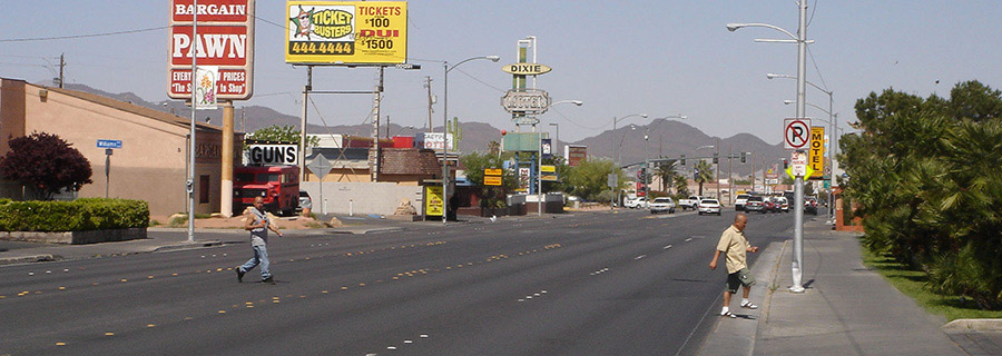
In the absence of modern wayfinding elements, the historic urban cores of towns and cities in the United States, bazaars and temple cities in Asia, and historic commercial corridors and religious centers in Europe have typically relied on a multiple senses to advertise key destinations and individual wares. In the process, these cities and towns created a unique multisensory experience that provides some lessons for designing wayfinding in our modern cities today.
The new approach to wayfinding needs to build on recent research and past best practices, and incorporate new concepts to make our streets more legible.
[1] Tuan, Yi-Fu. Space and Place: the Perspective of Experience. University of Minnesota Press, 2001.
[2] "MIT Research - Brain Processing of Visual Information." MIT News Office, 19 Dec. 1996. Web. 21 June 2011. http://web.mit.edu/newsoffice/1996/visualprocessing.html.
[3] Universal Design of state principles
Wayfinding design should aim to meet the following overall goals:
- Develop accurate and universally accessible wayfinding tools for a variety of activities and the full range of users of all ages and abilities.
- Maximize wayfinding systems that facilitate a more complete experience of the site by designing for all five senses.
- Enhance both legibility and understanding of the site with the appropriate selection of wayfinding features, minimizing undesirable clutter.
- Ensure that wayfinding features, including styles, materials, colors, etc., strengthen sense of place.
- Develop wayfinding tools that are flexible and responsive to adapt to evolving communication technologies and media.
Wayfinding design should address a diversity of activities including but not limited to:
- Locating
- Orienting
- Informing
- Guiding
- Interpreting
- Computing
Types of wayfinding include but are not limited to:
- Conventional wayfinding is primarily communicated by visual media and consists of static markers with words, symbols, colors, maps, etc.
- Multisensory wayfinding uses media to cater to all five senses – sight, touch, smell, taste and hearing. In addition to visual elements, it includes auditory, olfactory and tactile elements, such as audible signaling devices, 3-D relief maps, tactile warning strips, sweet scented trees, herbs and flowers, etc. This comprehensive approach has universal appeal, and has been informally practiced in historic towns and cities. It is regaining popularity, and is especially useful to people with mobility or visual impairments.
- Electronic wayfinding is primarily communicated through emerging technology and smart media, such as LED displays, interactive kiosks and mobile wayfinding devices (smartphones).
- Inclusive wayfinding is a universal design approach to wayfinding. It combines many of the above wayfinding types to allow users of different ages and abilities to equally understand and participate.
These wayfinding types can be accommodated in a variety of locations within the street or public right-of-way, such as sidewalks, plazas, bulbouts, parking lanes, medians, or travel lanes. However, new personal mobility devices, such as cellphones, smartphones and similar GPS navigation instruments, have immensely increased the legibility of spaces.
A combination of elements and objects are essential to the design of streets with great wayfinding. All these elements also must be considered in terms of access for people of all ages and abilities. This includes but is not limited to:
- Street signs should be made of durable, non-reflective materials with high contrast printing. These may include:
- Directional signs
- Identification (destination) signs
- Regulatory, safety, advisory or prohibition signs
- Print or digital informational signs (e.g., maps, interpretative features, orientation, schedules, routes, etc.)
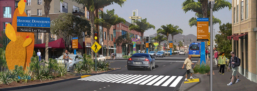
- Decorative wayfinding elements create identity for an area, help orient people to their location, provide focal points and also may have a functional use.
- Banners on light poles with street, neighborhood or district names, etc.
- Pendant lighting
- Special pavement patterns and designs that relate to the characteristics of a location, including illuminated pavement
- Custom logos that emphasize a street brand
- Custom-designed street furniture (e.g., tree grates, bollards, light poles, etc.)
- Staffed and unstaffed kiosks or booths are small structures positioned along streets, parks, trails and plazas that provide orientation information, such as digital and printed maps, touch-screen computer interface, schedules or other interpretive elements.
- Memorials, landmarks and gateways are structures that typically relate to a significant intersection, crossroad, building, historical event, person(s), social movement or geographical feature. Landmarks can help people with cognitive disabilities mark and recall a path to a destination point.[4]
- Fountains
- Street arches
- Pedestals
- Plaques
- Statues
- Historical buildings
- Planting design (e.g., allee or grove of trees)
- Streetscape art, especially interpretive art, helps orient people and provides a welcome moment in the urban experience. Often used in conjunction with plazas, street corners and buildings, streetscape art can include the following:
- Sculpture
- Lighting design
- Murals
- Reliefs
- Statues
- Other
- Motion/pressure detectors help improve accessibility of and within destinations by removing physical and psychological barriers for people with vision or mobility disabilities. As a wayfinding element along streets, motion/pressure detectors are often used in conjunction with building or transit entrances, crosswalks and display/exhibit information.
- Tactile wayfinding elements assist people in better understanding their environment using senses other than sight.
- Tactile 3-D map displays with raised lines and texture fills depicting layout and circulation routes
- Braille signage
- Tactile ground plane materials (textured materials secured to the ground to help inform people of oncoming intersections or traffic/crossing hazards)
- Olfactory wayfinding elements assist people in better understanding their environment in powerful ways. The sense of smell is the strongest sense.
- Naturally scented trees, flowers and herbs
- Outdoor displays and activities of commerce such as outdoor dining, outdoor stands of fruits and vegetable, etc.
- Auditory wayfinding elements are part of the streetscape environment. These elements are often unintentionally provided as street noise caused by moving vehicles, braking, etc. The change in intensity of street noise along an individual street or between two nearby streets can be a useful wayfinding cue for people with visual impairments. Other intentional examples include:
- Talking signs that use the infrared audible signage system (These consist of short audio signals sent by visible infrared light beams from installed transmitters to a hand-held receiver. The receiver decodes the signal and delivers the voice message through its speaker or headset.)
- Audio maps, signs and talking signals at crosswalks
- Piped music from individual shops and stores, etc.
- Formal and informal performances at street nodes or special events
- Singing water features such as musical fountains, etc.
- Smartphones and mobile applications are the newest wayfinding technologies and have numerous applications in streetscape environments. As the majority of individuals gain access to personal mobile devices, traditional wayfinding elements, such as kiosks and map stations, may become redundant. Smartphone applications in a street setting can be used for the following:
- Walking tours that use QR (quick response) coded site information (Uses a small, bar code-like image that can be read by any smartphone and generally links to a website or other online media)
- Downloadable walking maps
- Downloadable directions to specific destinations such as individual stores, offices, residences, special events
- Walking distances between destinations tracked by GPS enabled apps
[4] Salmi, Patricia. "Wayfinding Design: Hidden Barriers to Universal Access." Implications 5 (Aug. 2005): 8. InformeDesign. Regents of the University of Minnesota, Aug. 2005. Web. 21 June 2011. <http://www.informedesign.org/_news/aug_v05r-p.pdf>.