Mobility is defined as the ability of people of all ages and abilities to move from one place to another.
Dirt, paved, brick, cobble, stone, concrete or asphalt, the street as a public right-of-way (ROW) has served the mobility of humans for hundreds of years. Streets have continuously evolved to accommodate new modes of transportation. Unfortunately, towards the last part of the 20th century, the automobile increasingly took over and, in many ways, overwhelmed pedestrians, bicyclists and other users of the street. Recently though, many towns and cities have tried to reverse this trend, and some success has been achieved to better address the needs of pedestrians and bicyclists, especially as part of the complete street movement.
Building on the principles of the Complete Streets and Livable Streets movement, this topic focuses on ways in which the street can better serve the mobility needs of all users, especially the most vulnerable users (children, elderly and disabled) and transportation modes (pedestrians and bicyclists). Relatively new approaches to travel way design in America, such as multi-way boulevards and corridors with roundabouts, have successfully maintained or increased the roadway capacity for automobiles while allowing streets to provide safer and more welcoming environments to pedestrians, cyclists and transit users. This topic also looks at how technological advances, especially in the fields of vehicle design, vehicle capacity management and operational systems, behoove us to create flexible streets that accommodate and encourage all modes of travel and balance the needs of all users.
Why Design Streets for Mobility
Traditionally, mobility in the streets is perceived to embody personal freedom, social emancipation and economic growth. Pedestrians and carriages were early modes of travel in the street ROW. The bicycle was introduced as a mode of transportation in the second decade of 1800s, and the first bike path in America opened 1894 running along the Ocean Parkway in Brooklyn. As bicycles became safer and cheaper, more women had access to the personal freedom, and the bicycle came to symbolize the New Woman of the late 19th century, especially in Britain and the United States.[1]
The popularity of the bicycle in the early 20th century coincided with the mass production of cars. Construction of a national roadway network, starting with the Lincoln Highway in 1913, the early national highway system in the 1920s and the more comprehensive Interstate Highway System in the 1950s, led to unprecedented growth in private transportation and mobility, and greatly contributed to the nation’s economic output. It made the automobile the preferred mode of transportation for most Americans and signaled the end of the railroads as the predominant method of transportation for people. Today, passenger transportation is dominated by private passenger vehicles (including cars, trucks, vans and motorcycles), which account for 86% of passenger-miles traveled.[2]
A vast amount of land -- more than for either parks or government buildings — is devoted to roads. More than four million miles of paved and unpaved roads make up the U.S. roadways. Excluding expressways (highways and freeways), more than 2.67 million miles of paved roads exist in our cities and towns.[3]
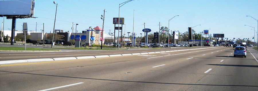
Yet the large amount of land devoted to our roads has not provided the desired mobility benefits. The 2010 Annual Urban Mobility Report found that traffic congestion cost the U.S. almost $115 billion in 2009. This costs the average commuter more than $800 and about 34 hours per year.[4] Unfortunately, the decades-long focus on automobile mobility at the expense of safety and mobility of the non-motorized users of the streets has resulted in unsafe and unfriendly pedestrian and bicycle environments. In the last decade, from 2000 through 2009, more than 47,700 pedestrians were killed in the U.S. In 2009 alone, about 63,000 pedestrians and 51,000 bicyclists were killed or injured in the U.S. In many places, including 15 of the country’s largest metropolitan areas, pedestrian fatalities have actually increased, even as overall traffic deaths fell. The majority of these deaths share a common thread: they occurred along “arterial” roadways that were dangerous by design, streets engineered for speeding traffic often with little or no provision for people on foot, in wheelchairs or on bicycles.[5]
Traditionally, our streets have never taken into account the needs of our most vulnerable users. One of the most important civil rights law to be enacted since the Civil Rights Act of 1964, the ADA prohibits discrimination against people with disabilities. However, it is only in the past few years that cities and towns have made an honest, concerted effort to make our public ROW universally accessible. More and more jurisdictions are retrofitting our sidewalks and crosswalks with ADA compliant ramps, cross slopes, and cues such as truncated domes. However, true universal accessibility on the street ROW is more than just replacing the curb at the intersection with a ramp. A more holistic approach to creating a universal environment is needed.
Parallel to the universal access movement, is a growing trend to create and enhance bicycle facilities in the U.S. The first bike lanes in the U.S. opened in Davis, CA in 1967 on Third Street and Sycamore Lane, which led to similar bike facilities in large and small cities including Boulder, CO and Portland, OR. The first separated bike lanes, similar to those that now exist on sections of Eighth and Ninth Avenues in Manhattan, were incorporated in 1980 on Avenue of the Americas and Seventh Avenue—though they were quickly removed amid fierce opposition.
Community desire to maximize alternative modes of transportation, including biking and walking, has dramatically increased, as has implementation. In New York alone, from 2006 to 2010, more than 250 miles of traffic lanes dedicated for bicycles have been created, and several laws intended to promote cycling have been passed.
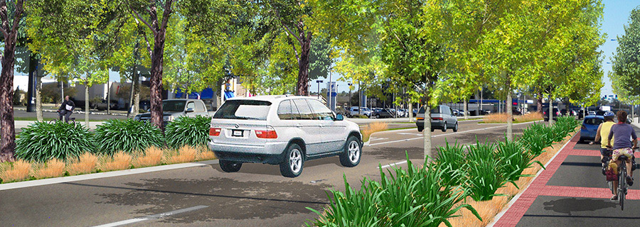
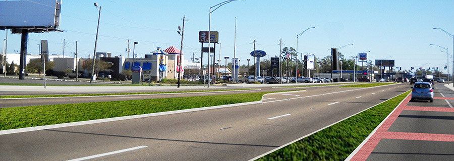
Similar improvements in other big cities and small towns have clearly shown the benefits of creating pedestrian and bicycle facilities, starting with a clear improvement in overall safety of street users and a dramatic decrease in accidents and injuries. More and more agencies are realizing that retrofitting existing roads to accommodate non-automobile users need not be viewed as always a “zero sum game.” Often, better or adequate mobility for pedestrians and bicyclists can be added without diminishing the mobility of motorists.
It has been shown that pedestrian and bicycle infrastructure construction projects also create more jobs than road construction improvement jobs.[6] Other studies have shown that investments in bicycle and pedestrian facilities clearly reduce carbon emissions and improve quality of life.
Similarly, recent approaches to moving traffic, managing travel demand and applying new technology are enabling us to better manage traffic capacity and ensure that the multi-modal mobility balance in our streets can continue to improve, providing social and economic benefits to our community.
[3] The World Factbook, Central Intelligence Agency (CIA), https://www.cia.gov/library/publications/the-world-factbook/geos/us.html (last updated June 14, 2011)
[4] "2010 Annual Urban Mobility Report"
[5] An analysis by Transportation for America documented in "2011 Dangerous by Design, Solving the Epidemic of Preventable Pedestrian Deaths, of NHTSA’s Fatality Analysis Reporting System" shows that 52% of all pedestrian deaths were on principal or minor arterials and 60% of pedestrian deaths were on roads with speeds of 40m/hr or higher.
[6] Heidi Garrett-Peltier, "Estimating the Employment Impacts of Pedestrian, bicycle and road infrastructure, Case Study – Baltimore", shows that road construction jobs create approximately 7 jobs per $1 million spending, pedestrian projects create over 11 jobs for the same level of spending, and bicycle projects create up to 14 jobs.
Design for mobility and access should aim to meet the following overall goals:
- Design streets to accommodate ALL users of all ages and abilities including pedestrians, bicyclists, transit users and automobile drivers.
- Ensure speeds respect the desired role and character of the street including the type and intensity of land use; urban form; the desired activities on the sidewalk such as outdoor dining; and the overall safety and comfort of all modes.
- Incorporate flexibility in the design of the street to accommodate increasing multi-modal mobility needs, technological advances and allowances for placemaking.
- Maximize multi-objective roles for individual streetscape elements and objects.
Mobility and access should be designed to promote a diversity of street activities including but not limited to:
- Walking
- Running
- Biking
- Rolling
- Riding
- Stepping
- Climbing
- Driving
- Learning
- Parking
- Loading, unloading, etc.
- Other
It is important to identify each street’s purpose and use within the larger roadway network to determine the design goals of the street. Streets have been classified in a number of ways. Usually the classification has appeared to prioritize vehicular traffic over other modes. Since the 1930s, traffic engineers have routinely classified every roadway in a hierarchy according to the degree to which it serves either traffic movement or access.[7]
Most conventional road hierarchy is based on functional classification. However, the function of most major corridors has been to move vehicular traffic as fast as possible. Recently, as part of the living and complete streets movement, there has been a growing discussion about how function is defined, how the travel way is allocated, how street type relates to position in the street pattern, and how the hierarchical structure of our streets should be categorized.
Most jurisdictions have based their street system on the following the American Association of State Highway and Transportation Officials (AASHTO) model detailed below. Recent approaches have changed the model to be more sensitive to land use context and the needs of the non-motorized users, especially pedestrians and bicyclists. This new way of thinking about streets does not require abandoning the highway functional classification system. Rather it is an amplification of the uses of high volume and fast moving roadways, especially thoroughfares or arterials. Specifically, the recent approaches allow new categories and the descriptions of these categories include ways for pedestrians and bicyclists to travel along and across those types of streets. Following are the various systems:
1. Traditional AASHTO system: Typically, the role of the roadway in the network is determined by the level of mobility provided to automobile traffic by that roadway. In general, the mobility function decreases as automobile access increases.[8] Thus in urban and rural settings the street types are primarily based on automobile traffic needs and can be broadly laid out in the following manner:
- Principal and minor arterial roads (for both urban and rural settings) serve corridors with long trip length and high volumes.
- Collectors (for urban setting and major and minor collectors for rural settings) serve subordinate traffic generators.
- Local streets (for both urban and rural settings) provide access as well as local circulation.
2. Context Sensitive Solution For Thoroughfare system: Developed as part of a joint effort between the Institute of Transportation Engineers (ITE) and the Congress for the New Urbanism and sponsored by the Federal Highway Administration and the Environmental Protection Agency, this system provides an ITE-proposed recommended practice to supplement existing AASHTO polices and information. Very broadly, the system has the following types of thoroughfare streets:
- Freeway/expressway/parkways
- Rural highway
- Boulevard
- Avenue
- Street
- Rural road
- Alley/rear lane
3. Customized system of street types (Charlotte, NC model): Responding to the specific needs of their jurisdictions, cities such as Charlotte and DoTs such as NCDoT have created a more context-sensitive street classification. Charlotte’s typology is based on meeting the overarching goals of supporting economic development and quality of life, providing more and safer transportation choices, and better integrating land use and transportation. It included the following five street types:
- Parkways primarily move automobiles, and typically their needs are favored over other modes.
- Boulevards move large numbers of vehicles as through traffic from one part of the city to other lower levels of streets in the network. Automobiles are the priority, but boulevards provide for pedestrians and bicyclists as well.
- Avenues provide access from neighborhoods to commercial areas and are designed to provide a balance of service for all modes of transport, including pedestrians, bicyclists and automobiles.
- Main streets are the most pedestrian-friendly streets, and serve as destination streets, providing access to and functioning as centers of civic, social and commercial activity.
- Local streets with low speeds and traffic volumes provide access to residential, commercial, industrial and mixed use areas.
4. Other: Similar to the Charlotte model, other jurisdictions such as Denver, CO and Richmond,CA , are developing a street classification that meets the specific needs of their community.
[7] Paul Barter, Earning a Public Space Dividend in the Street, Journeys, 2009
[8] Norman W.Garrick and Tobias Kuhnimhof, Street Design and Community Livability extract from Proceedings of Urban Transportation 2000, Cambridge, UK 26-28 July 2000
A combination of the following elements is essential to the design of balanced mobility. This includes but is not limited to:
- Pedestrian paths of travel, such as sidewalks, escalators, paths, etc.
- Travel lanes, such as bike lanes, vehicular traffic lanes, public transit (bus, streetcar and light rail) lanes, shared lanes, flexible lanes, etc.
- Parking lanes serve various types of on-street parking (regulated, temporary, etc.),and in urban areas, also serve as loading and unloading areas for service vehicles.
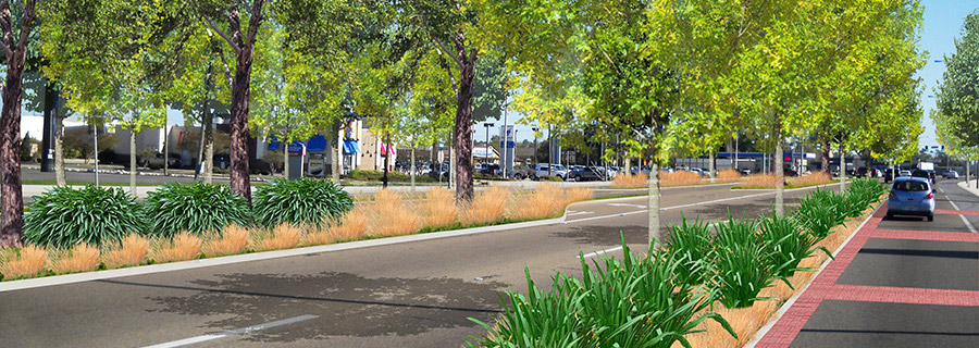
- Medians, planted or paved, located in the middle of the road or at the side of the road as part of multi-way boulevards.
- Landscaped elements, such as trees, shrubs and grasses, located in planting strips, medians, grates, etc.
- Sidewalk extensions, such as bulbouts at intersections or in the middle of the block, reduce crosswalk distances and provide additional opportunities for planting, commerce and social gathering.
- Crosswalks at the intersection or between intersections.
- Signs and markings serving different users of the streets, including stop signs, street name signs, centerline striping, colored curbs, crosswalks and other pavement markings.
- Bike facilities, such as bike racks and rental facilities.
- Lighting that is usually a raised source of light and, depending on the height of the light, serves at street level, pedestrian or bollard level.
- Transit stops along public transit routes served by buses, streetcars and light rail designate a place for passenger loading or unloading.
- Shelters at transit stops provide protection from the elements and a place to sit and wait.
- Traffic calming devices, such as roundabouts, traffic circles, speed bumps, chicanes, etc.
- ADA elements and sensory cue devices, such as truncated domes, talking signals, ramps, resources for service dogs, etc.
- Curbs are traditionally the edge of the roadway where a raised pavement such as a sidewalk meets the unraised road or shoulder.
- Gutters such as ‘v’ gutters located in the middle of the roadway or more conventionally at the curb, help transport storm water runoff.
- Permanent and temporary lane indicators, such as striping, SmartStuds, etc.
- Signaling devices, such as traffic signals, stoplights, traffic lamps and stop-and-go lights, usually positioned at road intersections, pedestrian crossings and other locations to control competing flows of traffic.
- Other streetscape elements, such as bollards, parking meters, etc.