New York, NY
Background
As it crosses the grid, Broadway's configuration in New York City’s Midtown caused some of the city's worst traffic back-ups and most hazardous pedestrian conditions. The stretch of Broadway included in the Green Light for Midtown pilot project witnessed 562 crashes involving pedestrians and motor vehicles between 1995 and 2005, according to Crashstat.org, making it one of the most dangerous stretches of roadway for walkers in all of New York City. By reducing traffic congestion, Broadway will once again become New York City's great walking street, perennial traffic back-ups will be solved and lives will be saved.
Adopted from: Transportation Alternatives

Between the gushing reviews of the new urban space and glorious pictures of pedestrian packed streets, it is easy to forget that the city’s Greenlight for Midtown program was primarily billed as a way to reduce traffic congestion throughout Manhattan by the most counter-intuitive means: taking away space from cars. Although induced demand and its inverse, sometimes called traffic shrinkage, have become accepted in transportation-planning circles, to have a concrete and beach chair-filled example of it at the crossroads of the world is an obvious boon for those who wish to make the case that closing streets to cars, rationalizing intersections and improving the pedestrian environment can be a sensible solution to vehicle congestion.

The redesign has been a success, not only in its much-lauded efforts to give pedestrians a bit more breathing room, but also as a counter-intuitive traffic curative for all the world to see. The project included several phases, including an initial visioning project by Project for Public Spaces, temporary changes and evaluation of results initiated by the New York City Department of Transportation (NYCDOT), and semipermanent designs. Construction of permanent plazas is anticipated in 2012.
Adopted from: Beck and Graham, 2009
Project for Public Places
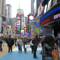
Still one of New York’s main draws, Times Square had become increasingly been a place where no one wanted to spend any time. Tourists, locals, and office workers were unsatisfied with their experiences there. Times Square offered little amenity or activity beyond its initial visual impact and, therefore, lacked a critical quality of every successful public space—it did not make you want to go back.
The Times Square Alliance hired Project for Public Spaces (PPS) from May 2006 to June 2007 to better understand and reimagine how Times Square performs as a public space. PPS began by gaining a better understanding of the district through systematic observation techniques such as time-lapse film analysis, activity mapping, and tracking and user surveys.
The general issues and opportunities that emerged from the analysis included:
- Ground floors: Most building bases did not support sidewalk activity, gathering and smaller destinations.
- No square there: Demand for use and activity in the median was very high, yet there were no amenities in the square to support this activity.
- Movement and circulation: Street design did not support pedestrian movement – there was a lack of sidewalk space and crosswalks, and crossing times were inadequate.
- Flexible spaces: The district needs flexibility to close side streets and Broadway at various times to facilitate planned events.
- Reach out like an octopus: The area is not perceived as a district. Side streets, especially the theater blocks, were underperforming as destinations in their own right.
With these issues in mind, PPS also conducted comprehensive research of international best practices, drawing specific lessons from how other places have addressed similar challenges. Working with the client, PPS then developed key programmatic recommendations and conceptual plans. Recommendations included reconfiguration of streets to better accommodate foot traffic and reduce the negative impacts of traffic; architectural treatments and amenities to improve the pedestrian experience; retail strategies to diversify the district’s attraction; and new public space programming, such as performances and markets.
To help the alliance sell this vision to its partners and constituents, PPS developed a series of photo-simulations depicting the vision. PPS also presented its observations, best practices research and programmatic recommendations to a selection of leading designers to explore ways that they could creatively respond to and build on PPS findings and recommendations.
In addition to changes being implemented by the business improvement district, the New York City Department of Transportation’s Green Light for Midtown project was informed by these recommendations.
Adopted from: Project for Public Spaces
New York City Department of Transportation
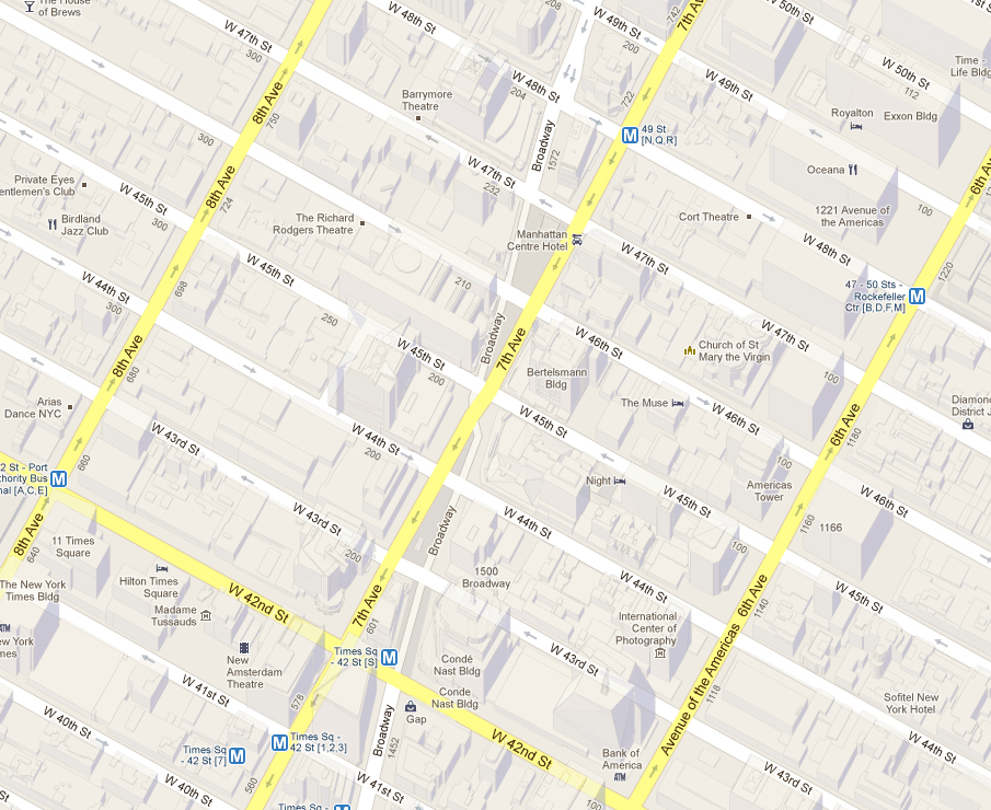
The New York City Department of Transportation began implementing Green Light for Midtown in late May 2009. The work created new pedestrian areas on Broadway in Times Square (47th to 42nd Streets) and Herald Square (35th to 33rd Streets). Extensive safety improvements were also made along the Broadway corridor between Columbus Circle and Madison Square.
A feasibility analysis indicated that the project would improve traffic flow on 6th and 7th Avenues as well as improve traffic safety along Broadway. Both before and after implementing the temporary pilot project, NYCDOT collected extensive data on travel times, traffic volumes, pedestrian volumes and traffic accidents in the months just prior and just following project implementation. According to that data, the project delivered on its expectations.
Findings from data from GPS units placed in taxis helped NYCDOT understand the impacts to travel in and around midtown:
- Travel speeds for northbound trips throughout West Midtown improved 17% from fall 2008 to 2009, compared with 8% in East Midtown.
- Travel speeds for southbound trips in West Midtown fell by 2% while East Midtown showed an increase of 3%.
- The speed of eastbound trips increased by 5% and westbound trips increased by 9% over the same time period.
- Bus travel speeds increased by 13% on 6th Avenue and fell by 2% on 7th Avenue.
Safety has also been vastly improved as a result of this project:
- Injuries to motorists and passengers in the project area are down 63%.
- Pedestrian injuries are down 35%.
- 80% fewer pedestrians are walking in the roadway in Times Square.
And the project has had additional benefits as well:
- 74% of New Yorkers surveyed by the Times Square Alliance agree that Times Square has improved dramatically over the last year.
- The number of people walking along Broadway and 7th Avenue in Times Square is up 11% and pedestrian volume is up 6% in Herald Square.
Based on these findings, plans are underway to make the Broadway changes permanent, including designing and building the plazas and corridor treatments with permanent, high quality materials. The NYCDOT also has completed the design of similar improvements to Union Square.
Adopted from: New York City Department of Transportation
reNEWable Times Square: Designing Temporary Surface Treatments
A winning design was selected to refresh and revive the streetscape designs currently at the Times Square pedestrian plazas while DOT moves forward with the area's permanent capital reconstruction project. Construction on the permanent plazas is expected in 2012.
Submitted by Brooklyn-based artist Molly Dilworth, the selected design is a graphic representation of NASA's infrared satellite data of Manhattan. Titled “Cool Water, Hot Island,” the artist's concept focuses on the urban heat-island effect, where cities experience warmer temperatures than rural settings. The proposed design's color palette of striking blues and whites reflects more sunlight and absorb less heat -- improving the look of these popular pedestrian plazas while making them more comfortable to sit in. The color and patterns evoke water, suggesting a river flowing through the center of Times Square, and they also provide a compelling visual counterpoint to the reds, oranges and yellows of the area's signature marquees and billboards.
Lessons Learned
Potential Benefits:
- Increases traffic flow by reducing the space devoted to vehicles in a highly visible location.
- Increases pedestrian safety and the number of pedestrians walking in the area.
- Provides amenities that supports social gathering.
- Increases sense of place.
- Utilizes temporary changes to collect data to support permanent change.
- Builds support for the changes through temporary surface treatments.
- Increases the visibility and attractiveness of pedestrian realm.
- Increases sidewalk activities, such as outdoor seating.
- Enhances pedestrian movement and circulation.
- Provides flexible spaces for special events, social gathering, and street performances.
Potential Issues:
- Impacts to businesses: There was initial resistance and fear from adjoining businesses about the potential impact.
- Initial resistance: There was initial resistance from users of transportation modes, such as private automobiles, taxis, tourist operators, etc.
Sources
Beck, Graham, May 29th, 2009. “Broadway: The Counter-Intuitive Traffic Curative,” Urban Omnibus, (http://urbanomnibus.net/2009/05/broadway-the-counter-intuitive-traffic-curative/)
New York City Department of Transportation, “Broadway” (http://www.nyc.gov/html/dot/html/about/broadway.shtml)
Project for Public Spaces “Times Square”
(http://www.pps.org/projects/timessquare/)
Transportation Alternatives (local biking, walking and transit advocacy group), February 26, 2009.
Statement on Broadway's Pedestrian-Friendly Redesign
(http://www.transalt.org/newsroom/releases/3079)
Photo Sources
MIG, Inc.