Background
The wayfinding systems used by Portland (Portland Central City Pedestrian Wayfinding Signage Project) and Philadelphia (Walk!Philadelphia) use similar aesthetics for static signage to connect districts and highlight transportation features.
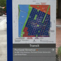
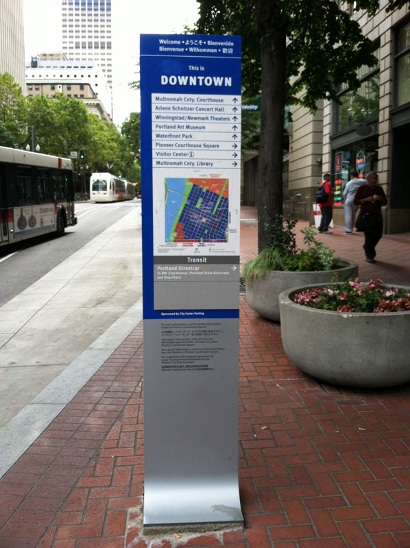
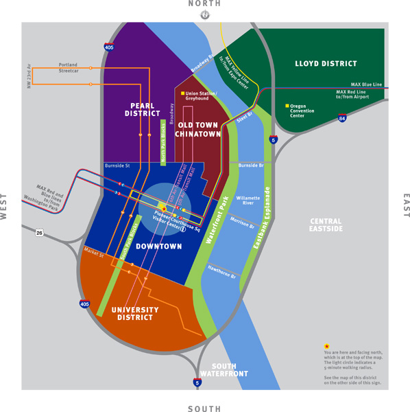
In Downtown Portland, the wayfinding system connects people to shopping districts, public plazas, waterfronts, museums, landmarks and gateways. The system links people to high-quality transit options, such as MAX Light Rail, city streetcar and bus service. Color-coded signs and map elements create a destination hierarchy and simplify understanding of the city’s layout. The wayfinding elements in Portland include free-standing, ground-mounted signage that use a combination of location identifying text (e.g., Downtown, Pearl District, Goose Hollow, etc.), directional signs and maps that help pedestrians navigate between major regional destinations, parks, historic sites, neighborhood attractions, and transit stops. A list of simple icons and the vibrant color palette make map reading effortless. Portable versions of walking maps are available and distributed by downtown businesses. In the future, it is conceivable that smart phone apps will reduce the need for printed maps.
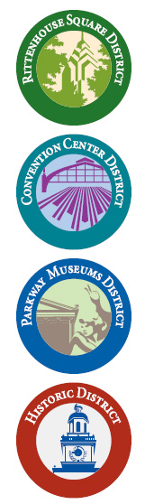
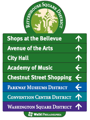
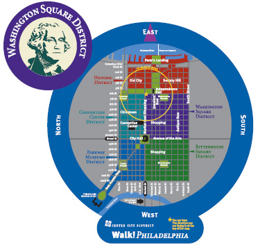
The Walk!Philadephia wayfinding system also organizes navigation around the presence of distinctive city districts, such as the Convention Center, Rittenhouse Square District and the Historic District (Old City). Signage emphasizes the ease of walking in the city. Color-coded ”heads up” disk-maps include comfortable 10-minute walking radii that highlight nearby destinations. Route choice is reinforced with simple directional arrows. The Walk!Philadelphia project also developed simple two-color branded logos for its five downtown districts, which highlight the iconic features you encounter while walking through the city.
Any static wayfinding system experiences awkward growing pains as the city continually develops and matures around it.
Lessons Learned
Potential Benefits:
- Makes it inviting and easy for visitors to hop on and off transit downtown.
- Makes destinations easy to locate through the use of simplified graphic design, bright colors, clear typeface choice and regularly spaced placement of signs along streets.
- Provides opportunities to fund upkeep through a sponsorship program that allows any businesses, public agency, non-profit organization or professional service provider to choose what signs they want to sponsor and makes their name visible to hundreds (thousands) of people per day (Portland).
Potential Issues:
- Multiple sign systems: The Center City District of Philadelphia had to develop a parallel signage system for visitors entering the city by vehicle, named Direction Philadelphia. Direction Philadelphia signs use fewer colors than Walk!Philadelphia signs, but they are similar enough that pedestrians may think they are the same thing or be thrown off slightly.
- Inaccurate signage: Ongoing Downtown Portland transit construction changed the locations of bus pick up areas and light rail lines were not updated on signage until construction was finished; signs were inaccurate for three years
- Graphic design: Simplified cardinal graphic conventions on both signage systems mean directional arrows sometimes don’t correctly point to destinations or travel routes.
Sources
Center City District. “Walk!Philadelphia” (http://www.centercityphila.org/docs/walkphila_infosheet.pdf)
Portland Bureau of Transportation. “Pedestrian Wayfinding Signs” (http://www.portlandonline.com/transportation/index.cfm?c=40500)
Photo Sources
MIG, Inc.